Ice, and what lies beneath

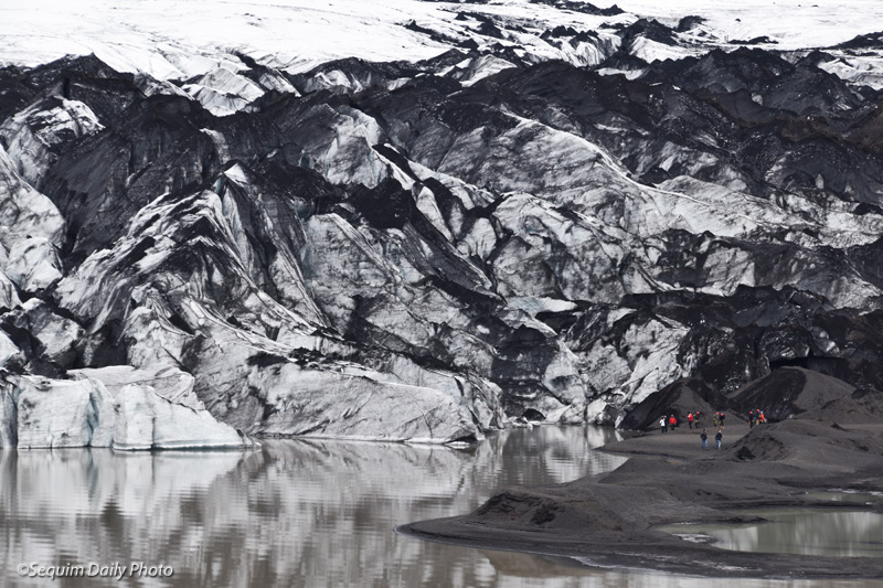
On one of two bus tours we visited Solheimajokull, part of the Myrdalsjokull Glacier. Iceland is a land of glaciers and this is the fourth largest, though like others around the world, this one is melting and retreating. To get an idea of the size of this glacial tongue, note the small, colored dots on the right of the shot above. Those are people.

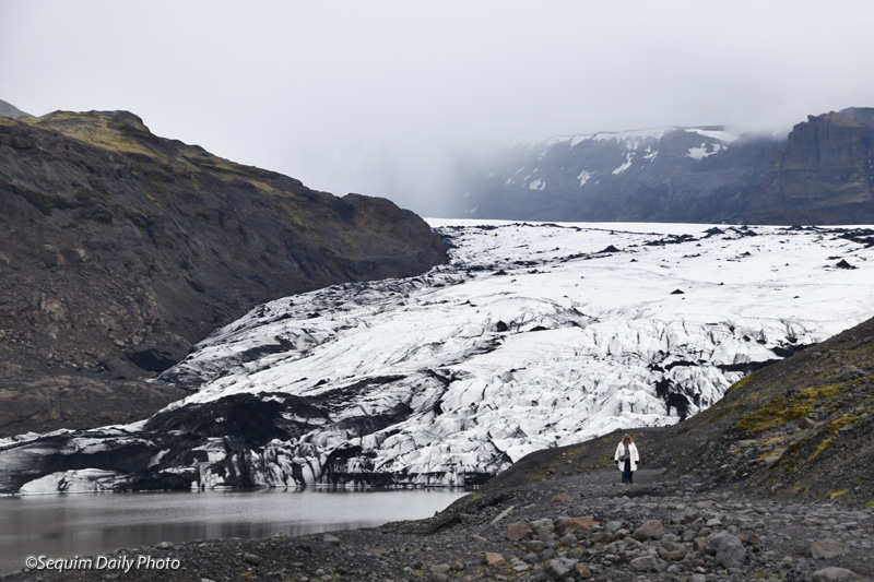
Several years ago, the land on the left side of this photo was covered by the glacier. As you can see, it’s now exposed and a small lake has formed at its base.

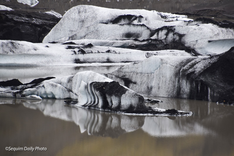
Huge blocks of ice have calved from the glacier and float in the lake below. The black that you see on the ice and glacier are ash from volcanic eruptions including one volcano, Katla, that is hidden beneath the glacier.

Katla, unlike erupting peaks that may be more familiar to us, erupts from under the glacier, causing enormous glacial outbursts as the ice melts into massive floodwaters that can cover surrounding lands and flow for days. It is also accompanied by dense ash like you see in these photos as well as toxic fumes. Since Iceland was settled (sometime after 700 A.D.) Katla has on average erupted twice a century. The last eruption was in 1918.

Melting glaciers present a unique danger in Iceland. The weight of the ice may serve to cap volcanic activity beneath them. Will the volcanoes become more active as the weight above them is reduced?

Geology and history

Here’s the biggest reason we went to Iceland: Pingvellir National Park, a spot so rich in geology and history that it’s a hotspot both of plate tectonics and a birthplace of Icelandic democracy.

First, tectonics: The rocky cliffs above? On the left is the North American plate. On the right is the Eurasian plate. These divergent plates meet in a rift zone roughly in the middle of Iceland. This fissure and others like it show the pull of these plates, moving apart at about the rate your fingernails grow each year. This is the only place in the world where this rift is above sea level.

In Sequim we live in a subduction zone where the Juan de Fuca Plate is slowly crashing into and diving under the North American Plate. In Iceland, the tectonics are the opposite: the plates diverge, moving slowly apart.

The fissures above were once liquid lava flowing from the earth’s molten center which is very close to the surface compared to other places on Earth.

Some of the fissures are filled with crystalline water. These waters can be explored by snorkeling and scuba diving.

These smaller waterfalls are on the Oxara River. It empties into the lake below.

The scenery is beautiful. The lake in the distance is the largest fissure of all in Pingvellir and it’s a dramatic example of the North Atlantic Rift.

And here is the center of the history in Pingvellir, the “Law Rock.” In around 930 A.D., about 60 years after settlement of Iceland, local chieftains from throughout the country began to meet annually at this site to work out consensus on critical issues and laws. These gatherings, called the Alpingi, continued for hundreds of years, changing after an alliance with Norway but continuing eventually as an appeals court until 1798.

Click here for more information about Iceland’s fascinating geology and here for background about Pingvellir history and a bit about geology.

More art scenery

Some of the murals I saw in Reykjavik were colorful, like this one.

And this one. Its colors seem to subtly wrap around the edge of the building on the horizontal panels, above left.

But the mural didn’t need to have a lot of color to be interesting, like this one in a residential area.

The detail was amazing.

Are you ready to see some of the other reasons we went to Iceland? I’ll show you tomorrow.

Art wins

When faced with graffiti, people in Reykjavik found that if they treated their blank walls as canvases and invited or commissioned art on them that there was less likelihood that they would be tagged. The result is a great array of art with many subjects and styles.

Many of the pieces I found were in downtown shopping areas.

It adorned parking structures.

I found it on courtyard walls, set back from streets.

And it certainly wasn’t boring. I’ll show you more tomorrow.

Art as scenery

It’s fun to discover public art in a new city. This basalt and bronze sculpture, “Unknown Bureaucrat,” by Magnus Tomasson, is found walking toward Reykjavik’s City Hall.

We found many other sculptures in parks and, like this one, in residential areas.

And there was fence art, too. Tomorrow I’ll show you what I found on some of the walls in Reykjavik.

The Reykjavik waterfront

Reykjavik’s Maritime Museum was high on our itinerary and it was one of the best we’ve visited. After a couple of other nearby stops we found ourselves at part of Reykjavik’s harbor.

It was a quiet time of day, though a nearby ship from Greenland was being loudly power washed in preparation for a new paint job.

As we moved closer to boats that make up the Icelandic fishery, DH pointed out these two boats, contemporary whalers. Iceland is one of the few countries in the world that has a whaling fleet. Whales are hunted for export to Japan and for domestic consumption. Apparently it’s popular with tourists.

Our seafood consumption was limited to fish and chips with the best, freshest cod I’ve ever eaten.

Kay’s Tourism 101

What makes a city interesting? In Reykjavik for me, certainly, it was the colors. And, on a grey day, the light that sliced through overcast after a day of gloom.

There’s a soothing presence of water, both as a feature of the city and by its nature as an island.

The tidy sensibility of Scandinavian design appeals.

And, for me, it’s always the pleasure of finding interesting and unusual details.